- Printed on Regular Paper (32lb)
- USGS topographic map of Preston, ID, at 1:250000 scale. High-quality paper print. Perfect for wall maps.
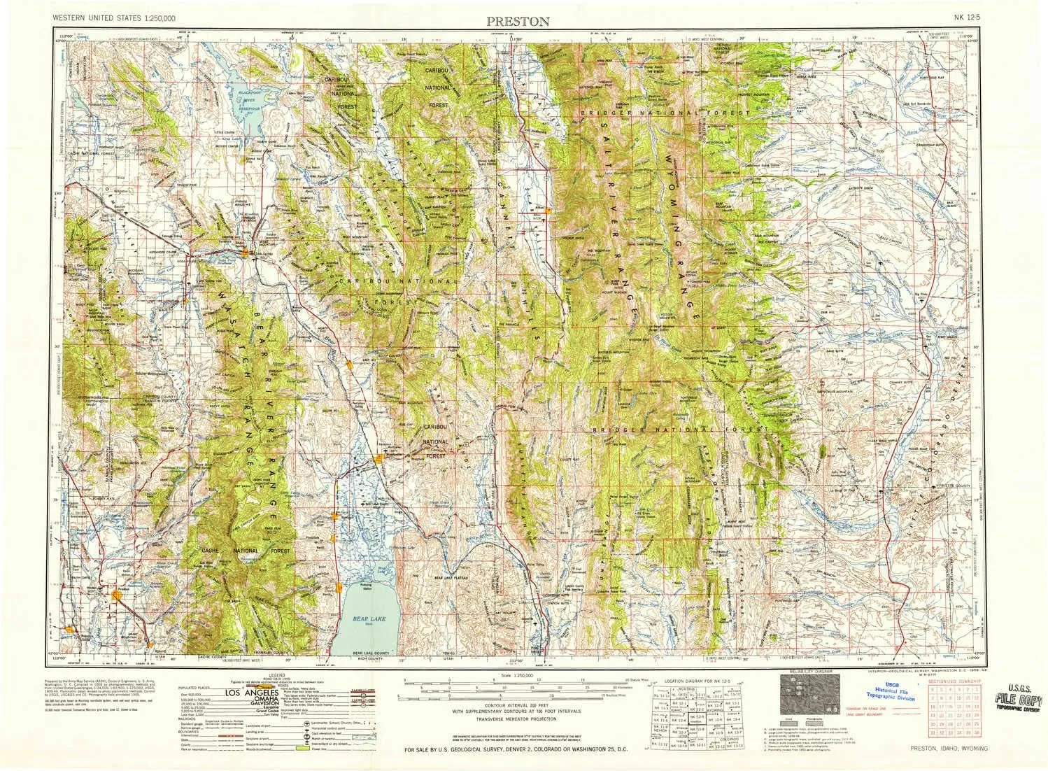
- Cities, towns, villages: Lago,Bench,Banida,Coulam,Marbleton,Turnerville,Border Junction,Bronx,Wayan,China Hill,Whitney,Bancroft,Smoot,Mound Valley,Grace,Lund,Treasureton,Bennington,Daniel Junction,Thorenson,Osmond,Paris,Riverdale,Central,Cherryville,Bear Lake Sands,Daniel,Weston,Harer,Ovid,Manson,Glencoe,Kinport,Raymond,Turner,Wardboro,Bloomington,Old Williamsburg (historical),Anderson,Mink Creek,Auburn,Silver Star,Fairview,Glendale,Thayne
- Rivers, creeks: Dry Basin Creek,Olsen Creek,Lake Fork Creek,Station Creek,Mill Creek,Smith Creek,Corral Creek,Big Jimmy Creek,Fivemile Creek,Little Beaver Creek,Dutch George Creek,South Fork North Horse Creek,Little Blackfoot River,North Twin Creek,Claudia Creek,Skinner Creek,Martha Creek,Pearson Creek,Corlos Creek,Lander Creek,Divide Creek,Trail Fork,Sjhoberg Creek,Booth Creek,Middle Fork South Piney Creek,West Meadow Canyon Creek,Spring Creek,South Fork Dry Creek,Chappel Creek
- Lakes: Lake Barstow,Bloomington Lake,The Narrows,Swift Creek Lake,Swan Lake,Cottonwood Lake,Gibson Lakes,Twin Creek Lakes,Roaring Fork Lakes,Crystal Lake,Dry Creek Lake,Soda Lake,Lake Alice,Mud Lake,Devils Hole Lakes,Blind Bull Lake,Blue Lake,South Three Forks Lakes,Burchett Lake,Swan Lake,Slide Lake,Crow Creek Lakes,Gronewell Lake,The Reservoir
USGS topographic map of Preston, Idaho, dated 1958.
Includes geographic coordinates (latitude and longitude), lines of elevation, bodies of water, roads, and more. This topo quad is suitable for recreational, outdoor uses, office applications, or wall map framing.
Printed on-demand by YellowMaps on the print material of your choice.
Shipping rolled from Minneapolis, MN, United States.
Product Number: USGS-5437712
Map Size: 22 inches high x 30 inches wide
Map Scale: 1:250000
Map Type: POD USGS Topographic Map
Map Series: HTMC
Map Version: Historical
Cell ID: 72243
Scan ID: 239667
Woodland Tint: Yes
Visual Version Number: 1
Aerial Photo Year: 1955
Field Check Year: 1955
Datum: Unstated
Map Projection: Transverse Mercator
Map published by United States Army Corps of Engineers
Map published by United States Army
Map Language: English
Scanner Resolution: 600 dpi
Map Cell Name: Preston
Grid size: 1 X 2 Degree
Date on map: 1958
Geographical region: Idaho, United States
Northern map edge Latitude: 43°
Southern map edge Latitude: 42°
Western map edge Longitude: -112°
Eastern map edge Longitude: -110°
Surrounding map sheets (copy & paste the Product No. in the search bar):
North: USGS-5431715,USGS-5437628,USGS-5679325,USGS-5437626,USGS-5437634
East: USGS-5610004,USGS-5610006,USGS-5618016,USGS-5618010,USGS-5618012
South: USGS-5461599,USGS-5463123,USGS-5463304,USGS-5463121,USGS-5463301
West: USGS-5437706,USGS-5676784,USGS-5658323,USGS-5437700,USGS-5658321


